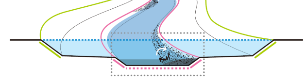
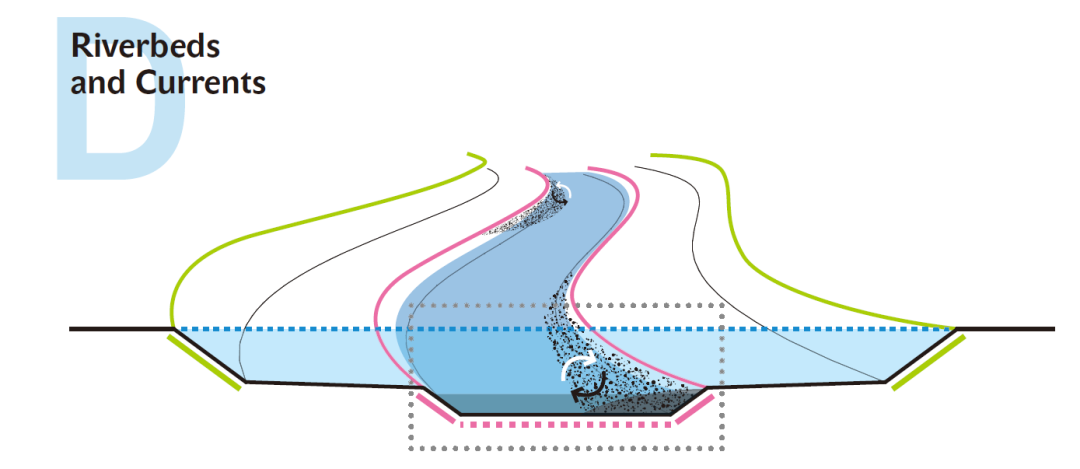
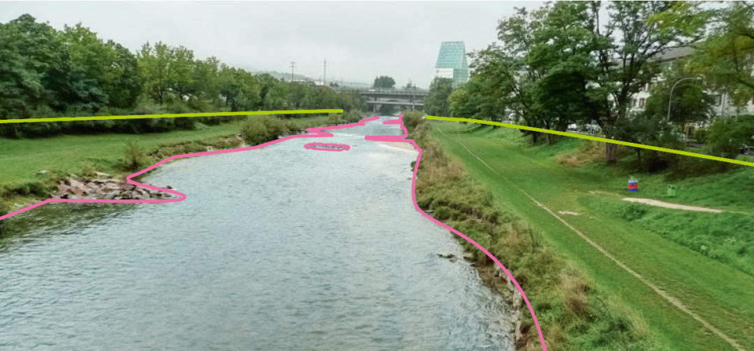
Process Space Dcomprises the riverbed between the banks or the riverbank reinforcementsthemselves, whose lines are immovable, thus forming the limit of self-dynamicriver channel development (red line). The defined flood limit (green line) andthe flood plain area between riverbank line and flood limit thus lie outsidethis Process Space and are not addressed here. Rather, the possibilities aredescribed of reshaping canalised, straightened watercourses within aconstricted area to allow morphodynamic processes to re-emerge. For this,unlike in Process Space E, the flood plain cannot be used as space for theriver channel to develop self-dynamically, and the fixed riverbank lines can beshifted only slightly, if at all, because open space close to the water isscarce or non-existent, or because it fulfils other functions such ascontaining underground cables and pipeline conduits. Sometimes there is noflood plain at all, for instance in the case of rivers that had been culverted.In many towns and cities, however, the aim of restoring straightened andcanalised rivers persists.
Just as inProcess Spaces A, B and C, temporary flow fluctuations are relevant as theymake themselves felt in both vertical rising of water levels and horizontalexpansion into the flood plain. Above and beyond this, within this ProcessSpace morphodynamic sedimentation processes on the riverbed are permittedand/or encouraged; erosion and sedimentation leads to constant changing of theriverbed with the creation of cut banks and slip-off slopes, scour holes,rapids and islands that convey the impression of a varied, near-natural river.Unlike in Process Space E, however, no alterations in the river’s coursethrough its inherent dynamics are permitted, as the urban river flood plain ofProcess Space D with its existing built-up surroundings or infrastructureallows no room for natural development. Therefore the river, like its formercondition, a drastically straightened watercourse, remains completely securedand controlled, and sediment shifts are only possible within a fixed framework.
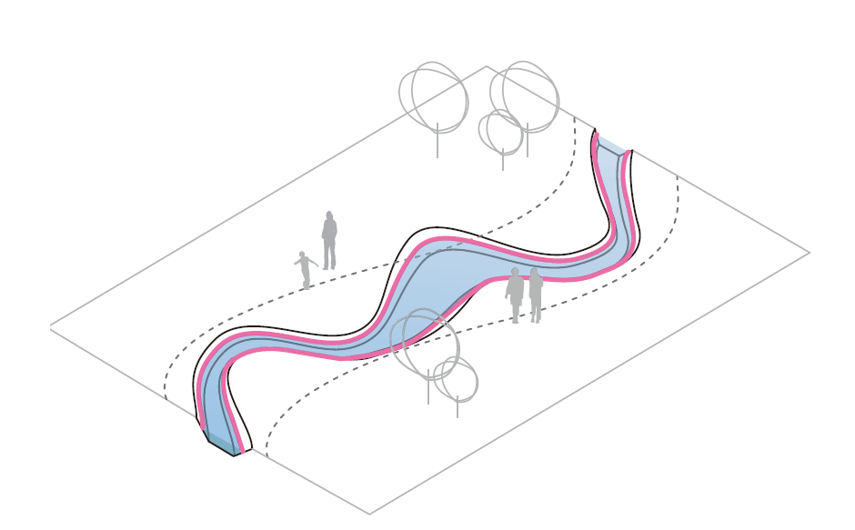
Within thisdefined area, then, conditions are created that resemble those of a naturalriver. As a rule this concerns small and medium-sized rivers whose channel maybe influenced by interventions on the riverbed that affect the flow. Inreshaping the riverbed, the typical characteristics and processes of a naturalwatercourse, which had been eradicated in the canalised river, are artificiallyrestored. The aim of many a river intervention in the past was to inhibiterosion as much as possible and to induce constant and steady current, as in acanal. The important design tools to instigate the greatest possible riverbeddynamic are current-altering elements to produce a differentiated flow scenariowith eddies, calm zones and rapids. Through this, sediment shifts can bedeliberately encouraged. By combining various current-deflecting elements andremodelling the medium and low water course, an artificial sinuous course withdifferent depths of water evolves between the fixed banks. Further designmeasures address the differentiated shaping of the indispensible bank andriverbed reinforcements.
The aim is todesign a river within the given limits in which as many natural water processesas possible can happen.
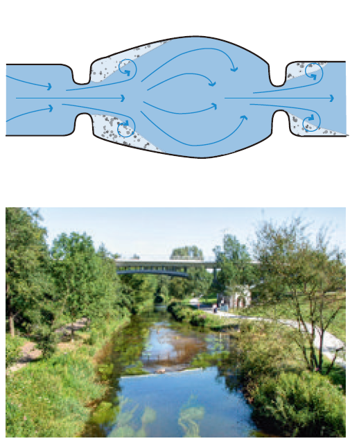
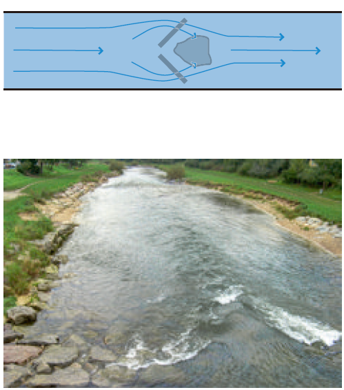
Installingcurrent-deflecting elements such as groynes or islands causes differentiationof the current, making its direction and the flow rates of the river apparentand tangible: rapids and eddies, but also calm zones. Variations in the currentactivate natural sediment shifting processes that can be guided by specificinstallation of current-altering elements. Depending on the flow rate, sedimentof various particle sizes will be removed or deposited, and varying riverbedsubstrates and depths will develop. For this to happen, a change of theexisting ground sills is necessary. Elements to secure the riverbed’s stabilitywill still be needed, but with differentiated, more permeable structures thathelp reinstate the passability of the river for living organisms as well asfacilitate sediment transportation.
As a rule thesesediment movements are reversible. At low water levels there is moreaggradation of riparian deposits, while at high water levels such deposits arecarried off by the stronger flow rate. It is only in very sheltered places thatpermanent aggradation zones arise. Erosion processes that alter the course of ariver channel are prevented by the bank and riverbed reinforcements. Taken as awhole, by deliberately permitting certain morphodynamic processes withinProcess Space D, a differentiated riverbed with shallow zones, rapids, scourholes and gravel banks is created. For city dwellers, the reshaping of acanalised river is a great enrichment of their habitat: within a small space,accessible, living and varied watercourses appear, giving the townscape a newappearance and providing quality recreational space.
Theinterventions in Process Space D make diversified river structures possible indensely built-up urban spaces. Reshaping the riverbank edges and installingmultifunctional current-deflecting elements creates a multiplicity ofaccessible places in and on the watercourse. Boulders and groynes to walk onmake direct contact with the water possible, aggradation zones encourage childrento play in and on the water. On larger rivers, popular places for bathing areestablished on gravel- and sandbanks – the living river spaces offer a contrastto the paved and built-up urban space and are valuable close-to-townrecreational areas for the city population.
When theriverbed is remodelled, the discharge cross-section changes, and disruptiveelements, current-deflecting objects and plant growth mean that resistance tothe flow is higher and flow rates will be slowed. This can raise water levelslocally during high water periods. By the same token, these measures oftencreate more retention capacity, thus relieving pressure on downstream areas.Where higher water levels cause problems they can be compensated for with a combinationof measures to enlarge the discharge cross-section, such as setting back thedike line or excavating the flood plain, if possible (see Process Space C).
Variations inthe current, differentiations in the riverbed substrate and various waterdepths offer wide structural diversity in the river and lead to the creation ofdiverse biotopes in the marginal and aquatic zones.
The location,forms and materials of the installed elements create new habitats; withbioengineering measures or in the gaps between loose stone embankments,sheltered places develop for various species of flora and fauna.
A further ecological objective of the Process Space Dprojects presented in this book is the formation of a low water channel in theriver so that lower-lying sections of the riverbed still carry water as fishhabitats even during longer dry periods. Also, the pass- ability of thewatercourse is reinstated, for instance by replacing ground sills with ramps,allowing fish and tiny organisms to migrate naturally. From an ecological pointof view, a process of ecological revitalisation sets in, as various species offish, amphibians and dragon- and damselflies return to the city.
河道分段Enhancingvariation of the entire watercourse can go beyond setting features to deflectthe current to encompass complete structural remodelling of the medium waterchannel; immediately after construction, the river will look completelydifferent within this section with its course made longer, with varied water depthsand altered riverbanks.
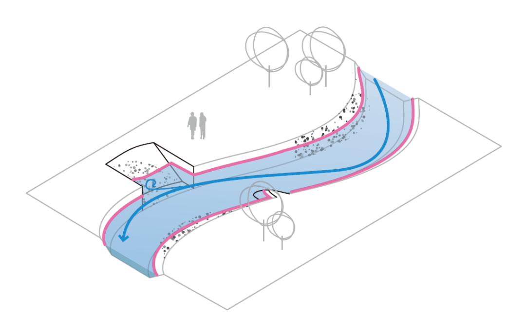
As a result,sediment shifting processes are set in motion that lead to variations incurrent strength, riverbed substrate and cross-section of the river channel.Widening the river creates zones with weaker currents where fords can develop.When widening a river it must be ensured that, even at low water level, thereis enough depth of water for migrating organisms. A sinuous formationencourages current variation and the deposit of sediments of various particlesizes. Flattening out the riverbank improves access, and creates ecologicallyinteresting transitional zones and calmer shallow areas along the river. Wherethe current can be diverted away from the banks by built structures, it ispossible to dispense with strong bank reinforcements. On a large scale this isalso possible on the slip-off banks of major rivers, as these become naturalaggradation zones virtually unaffected by erosive forces. Such grading createsa structurally rich riverbed with gently sloping foreshores and gravel banks,marginal areas and deeper zones for fish. By differentiating the river channelit is possible to create amenities, for example frequently used recreationalareas such as sandy beaches or quiet secluded spots for the enjoyment of nature.
Widening thecentral riverbed channel is possible if the bank reinforcements can be set backinto the flood plain somewhat. Such a measure can be made either at one spot asa bay or inlet, or as just a slight broadening of the watercourse. On the RiverAlb in Karlsruhe the widening was only possible on one side as there was nospace on the other. The widening lets the water flow more slowly at this point,and sand- and gravel banks arise. In calm zones the banks were flattened and smallbeach areas were created. The central channel can also be dramatically widenedto divide the stream and create an island. A further benefit of widening isthat it increases floodwater discharge capacity.
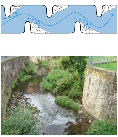
A combination of current-alteringelements and structural grading of the central channel deflects the flow into aseries of curves. This leads to more variation in the channel and thedevelopment of cut banks and slip-off banks. The length of the low- and mediumwater channel is extended. These graded sections must be protected againsterosion. Similarly to the way a river would develop naturally, the watercoursebecomes more varied. On the River Ahna in Kassel, lush riverside vegetation hascolonised the space so that the river appears like a green oasis in thetownscape.
延长流动长度
水流元素的改变和中央河道的结构分级相结合,使水流偏转成一系列的曲线。这导致了河道中更多的变化以及凹岸和凸岸的发展。低水和中水渠道的长度被延长。这些分级的部分必须得到保护以防止侵蚀。这种措施与河流自然发展的方式相似,水道变得更加多样。在卡塞尔的阿纳河上,郁郁葱葱的河边植被已经占据了空间,因此河流看起来像城市景观中的绿洲。延长流动长度 改变河床A differentiatedriverbed with various types of riverbank situations in the form of beaches,islands and scour holes corresponds with sound notions of riverrenaturalisation. These can, however, only be produced indirectly throughcurrent-deflecting devices, the purposeful exploitation of aggradation anderosion processes, and structural grading of the water channel. To encouragesedimentation processes that create islands and beaches, current-alteringelements or widening the channel at certain points are useful. These diffusethe current in specific sections, and according to the flow rate the tractiveforce changes and the suspended load up to a certain particle size isdeposited. Only when the current is very slow can fine material such as sandsettle, and thus influencing the current can determine whether a gravel or asandy aggradation emerges.
Conversely, thecreation of scour holes can be influenced by using current-deflecting elementsto create zones with stronger flow that intensify the erosion process. Beaches,islands and scour holes are the results of morphodynamic processes, and showthat a dynamic flow equilibrium has established itself within the riverbed.This also means, however, that under high water conditions, and a thus alteredinterplay of currents, aggradations can shift or vanish completely. Only insheltered bays or behind groynes permanent aggradation zones can establishthemselves, which are especially suitable as amenities in the summer in theform of easily accessible gravel- and sandy beaches that need littlemaintenance, whereas artificially laid beaches at inappropriate points on ariver have to be completely renewed after every flood event. In the light of dramaticallyimproved water quality, especially, the development of bathing places on riversis becoming increasingly important.
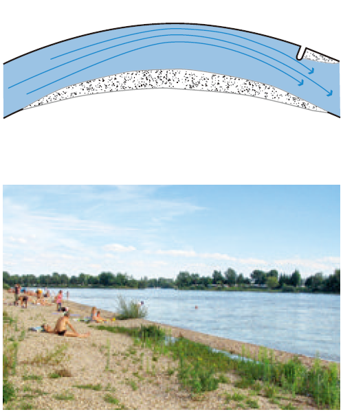
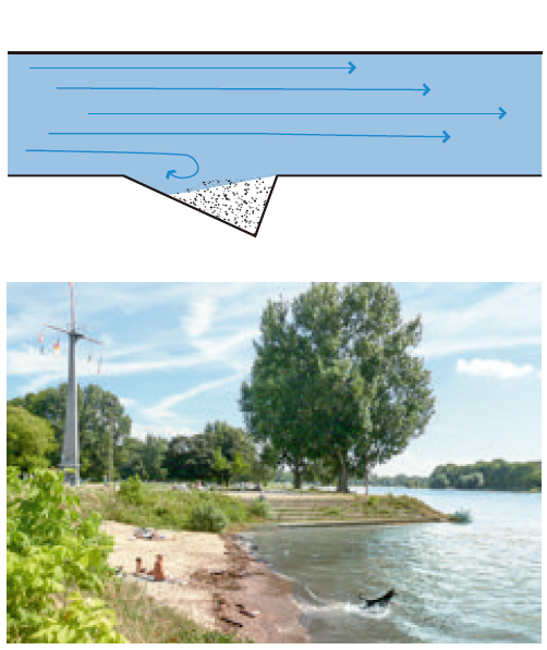
In calm zones along theslip-off slopes of rivers aggradation can occur and, depending on the flowrate, gravel or sand beaches are created. Natural beaches, for example on theReiß Island in the Rhine in Mannheim, are very popular places for play andrecreation. By setting current-deflecting elements in flowing water, artificialaggradation zones can be created and so, even in very narrow rivers, littlebeaches can emerge. In navigable waters rows of groynes can be placed along theedge of the channel between which little beaches can develop.
Widened bays inthe banks and artificial inlets create calm zones in the river and thusencourage sediment deposit, creating aggradation zones that can be used asbathing beaches at accessible points. On the River Rhine at Mannheim, a beachsituation could actually be developed under the cut bank. It is important toprotect the upstream corner of the bay against erosive eddies with areinforcement. The aggradation is determined by the form and size of thewidened bank section.
Current-deflecting elementscan be used to increase the flow rate in sections of a watercourse. If theriverbed is not sealed, as on the Birs in Basle, this concentration of thecurrent carries off bed material at one point and a scour hole is created. Suchdeeper points in the watercourse offer a special habitat and serve as refugesfor fish. A river’s current interplay alters with its flow fluctuations;erosion and sedimentation processes cause constant changes in the form of thescour holes.